Bus Stop Balancing
About the Project
Bus stop balancing involves the thoughtful removal and/or relocation of bus stops along a corridor to achieve more consistent spacing, maintain convenient access, and provide faster, more reliable service for our customers.
Fewer bus stops along a route means:
Faster and More Reliable Commutes
-
Improved overall trip times with more reliable buses and fewer delays
-
Maintain convenient access with five minutes or less of walking or rolling between most bus stops
Safer and Smoother Rides
-
More space on buses for physical distancing due to evenly distributed passenger loads
-
More comfortable rides with less stopping, starting, and lane changing
Benefits to Non-Riders
-
More curb space for parking, patios, or other uses
-
More sidewalk space to enhance physical distancing and accessibility
-
Improved traffic flow
While bus customers may sometimes walk a little bit further to their stop, their trip on the bus will be much shorter. On routes where we rebalanced bus stops, we achieved an average travel time savings ranging from approximately 4% to 14% throughout the day, translating to 3 to 6 minutes of saved travel time for our customers! Even more exciting, the savings achieved from bus stop balancing are reinvested into other high-traffic corridors within the municipality.
In addition to bus stop balancing, there are other bus-priority measures that TransLink implements in collaboration with municipalities to improve the speed and reliability of our buses and improve your experience.
Completed Routes
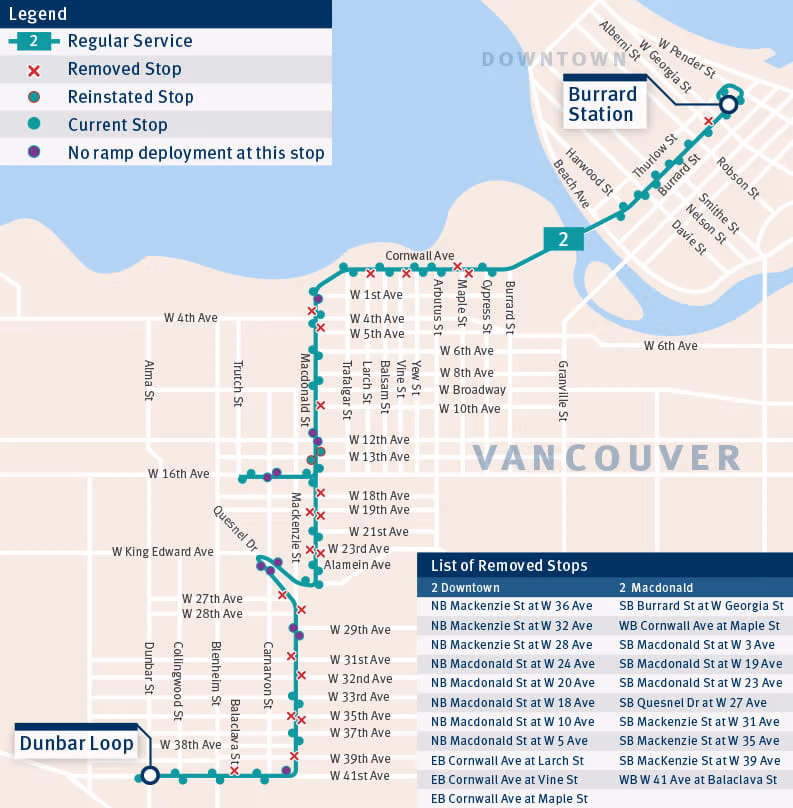
2 Macdonald/Downtown
Route 2 had some of the closest bus stop spacing in the region. Half of the bus stops were less than 205 metres apart (about two blocks), which is shorter than the distance between the SeaBus and Expo Line platform at Waterfront Station.
Following a successful bus stop balancing pilot project, we permanently removed some bus stops on Route 2 to improve travel times and reliability, effective November 9, 2020.
For Route 2 customers, this means:
-
Faster and more reliable commutes
-
Round trip savings of up to 4 minutes
-
Safer and smoother rides, more space for physical distancing, and more sidewalk space
We thank everyone who provided feedback. As a result, we have not removed two of the bus stops that we had initially proposed to remove.
The results of this pilot will help inform the roll out of our bus stop balancing program on other corridors across the region. To find out more about the Route 2 pilot project, read the Report on Line 2.
As a result of bus stop balancing completed on Route 2, customers can now save up to 6 minutes per round trip. During the busiest times of day, we’re saving up to 10 minutes on your journey.
List Of Removed Stops
-
SB BURRARD ST AT W GEORGIA ST – Stop # 50044
-
This bus stop will no longer serve Routes 2, 5, 32, and N22. However, it will continue to serve Route 44, which is temporarily suspended due to COVID-19. This means the stop will not be in use until route 44 is re-instated.
-
-
NB MACKENZIE ST AT W 36 AVE – Stop # 51260
-
NB MACKENZIE ST AT W 32 AVE – Stop # 51262
-
NB MACKENZIE ST AT W 28 AVE – Stop # 51264
-
NB MACDONALD ST AT W 24 AVE – Stop # 51268
-
NB MACDONALD ST AT W 20 AVE – Stop # 51270
-
NB MACDONALD ST AT W 18 AVE – Stop # 51271
-
NB MACDONALD ST AT W 13 AVE – Stop # 60359
-
NB MACDONALD ST AT W 10 AVE – Stop # 50059
-
NB MACDONALD ST AT W 5 AVE – Stop # 50062
-
EB CORNWALL AVE AT LARCH ST – Stop # 50066
-
EB CORNWALL AVE AT VINE ST – Stop # 50068
-
EB CORNWALL AVE AT MAPLE ST – Stop # 50071
-
WB CORNWALL AVE AT MAPLE ST – Stop # 50102
-
SB MACDONALD ST AT W 3 AVE – Stop # 50108
-
SB MACDONALD ST AT W 13 AVE – Stop # 50112
-
SB MACDONALD ST AT W 19 AVE – Stop # 50118
-
SB MACDONALD ST AT W 23 AVE – Stop # 50120
-
SB QUESNEL DR AT W 27 AVE – Stop # 50125
-
SB MACKENZIE ST AT W 31 AVE – Stop # 50127
-
SB MACKENZIE ST AT W 35 AVE – Stop # 50129
-
SB MACKENZIE ST AT W 39 AVE – Stop # 50131
-
WB W 41 AVE AT BALACLAVA ST – Stop # 50295
4 UBC/Powell
We’ve balanced bus stop spacing on Route 4 to improve travel times and reliability. Bus bulbs and other transit priority measures are coming to Kitsilano in Summer 2022.
Route 4 had some of the closest stops in the region. Two out of three stops (65%) were less than 300 metres apart (less than 2 blocks).
Following a successful bus stop balancing pilot project, we permanently removed some bus stops on Route 4 to improve travel times and reliability, effective Jan. 17, 2022. To minimize impacts on customers, we made changes to approximately one in six bus stops along Route 4.
When bus stops are too close or too far away, it's inconvenient for our customers. Removing, adding, and consolidating some bus stops means:
-
93% of customers do not need to adjust their journey,
-
savings of over 5 minutes per round trip in the busiest times of day,
-
bus stop balancing on Route 4 and 7 combined is expected to save $173,000 or 1,400 weekday service hours annually, which could be reinvested and reallocated to the routes that need it most.
We thank everyone who provided feedback. Having assessed public comments and feedback, all changes trialed on Jan. 17, 2022 will be made permanent.
Some other routes are affected by changes to Route 4. Please check the list of stop changes below.
Changes to Route 4 Powell – Eastbound
| Stop Name | Stop | Action | Other routes using stop |
|---|---|---|---|
| NB Blanca St at W 8 Ave | 50344 | Remove | |
| EB W 4 Ave at Dieppe Lane | 59298 | Remove | 42 |
| EB W 4 Ave at Highbury St | 50353 | Remove | |
| EB W 4 Ave at Waterloo St | 50390 | Remove | |
| EB W 4 Ave at Blenheim St | Add | ||
| EB W 4 Ave at Musqueamview St | 50391 | Remove | |
| EB W 4 Ave at Balaclava St | Add | ||
| EB W 4 Ave at Bayswater St | 50392 | Remove | |
| EB W 4 Ave at Larch St | 50395 | Remove | 14 |
| EB W 4 Ave at Vine St | 50397 | Remove | 14, 44, 84 |
| EB W 4 Ave at Yew St | Add | 14, 44, 84 | |
| EB W 4 Ave at Arbutus St | 50398 | Remove | 14 |
| EB W 4 Ave at Maple St | Add | 14 | |
| EB W 4 Ave at Cypress St | 50399 | Remove | 14 |
| EB Powell St at Mclean Dr | 50432 | Remove | 209 |
| NB N Nanaimo St at Cambridge St | 50439 | Remove | 209 |
| EB McGill St at N Kamloops St | 50441 | Remove | 209 |
| EB McGill St at N Renfrew St | 50444 | Remove |
Changes to Route 4 UBC – Westbound
| Stop Name | Stop | Action | Other routes using stop |
|---|---|---|---|
| WB Powell St at Woodland Dr | 50509 | Remove | 209 |
| WB W 4 Ave at Arbutus St | 50581 | Remove | 14 |
| WB W 4 Ave at Yew St | Add | 14, 44, 84 | |
| WB W 4 Ave at Vine St | 58299 | Remove | 14, 44, 84 |
| WB W 4 Ave at Bayswater St | 50586 | Remove | |
| WB W 4 Ave at 4000 Block | 50592 | Remove | 42 |
| WB W 4 Ave at Tolmie St | 50597 | Remove | |
| SB Blanca St at W 6 Ave | 50599 | Remove |
Click on the stop to see more details about why we recommended keeping, moving, or removing the bus stops.
Route map of the #4 showing consolidated and removed stops
| Keeping Bus Stop | New Bus Stop | Removing Bus Stop |
Interactive Map Key
-
Meets/Below spacing guidelines: TransLink’s Transit Service Guidelines, based on international best practises recommends an average spacing of 300 to 800 metres for all-day frequent routes.
-
Low ridership: Stop is used by less than 0.5% of the route’s riders.
-
No twin stop: There is not a bus stop across the road, which is used by that same bus in the opposite direction. This means customers alighting at a destination, may not be able to board the same bus to go back the way they came.
-
No crosswalk: A crosswalk ensures the safety of pedestrians and customers. It is especially important to have crosswalks close to bus stops.
-
Transfer point: This is a bus stop that attends to multiple different routes, or modes, allowing customers to transfer between them.
-
Terminus: This is the last stop on a bus route.
-
Serves a major destination: We have taken care to avoid removing bus stops near major destinations such as schools, hospitals, places of worship, seniors’ facilities, community centres etc.
-
Customer amenities: This could include a bus shelter, benches or lighting. We have avoided removing bus stops with multiple amenities to ensure our customers have a good transit experience.
7 Dunbar/Nanaimo
We’ve balanced the bus stop spacing and will be constructing bus bulbs at select stops on Route 7 to improve travel times and reliability. Bus bulbs and other transit priority measures are coming to Kitsilano in Summer 2022.
Route 7 had some of the closest stops in the region. Three out of four stops (77%) were less than 300 metres apart (less than 2 blocks).
Following a successful bus stop balancing pilot project, we permanently removed some bus stops on Route 4 to improve travel times and reliability, effective Jan. 17, 2022. To minimize impacts on customers, we made changes to approximately one in six bus stops along Route 7.
When bus stops are too close or too far away, it's inconvenient for our customers. Removing, adding, and consolidating some bus stops means:
-
92% of customers will not need to adjust their journey,
-
savings of over 5 minutes per round trip in the busiest times of day,
-
bus stop balancing on Route 4 and 7 combined is expected to save $173,000 or 1,400 weekday service hours annually, which could be reinvested and reallocated to the routes that need it most.
Thank You for Your Feedback
TWe thank everyone who provided feedback. Having assessed public comments and feedback, all changes trialed on Jan. 17, 2022 will be made permanent.
Some other routes may be affected by changes to Route 7. Please check the list of stop changes below.
Changes to Route 7 Nanaimo – Eastbound
| Stop Name | Stop | Action | Other routes using stop |
|---|---|---|---|
| NB Dunbar St at W 26 Ave | 50306 | Remove | |
| NB Dunbar St at W 16 Ave | 50311 | Remove | |
| EB W 4 Ave at Waterloo St | 50390 | Remove | |
| EB W 4 Ave at Blenheim St | Add | ||
| EB W 4 Ave at Musqueamview St | 50391 | Remove | |
| EB W 4 Ave at Balaclava St | Add | ||
| EB W 4 Ave at Bayswater St | 50392 | Remove | |
| EB W 4 Ave at Larch St | 50395 | Remove | 14 |
| EB W 4 Ave at Vine St | 50397 | Remove | 14, 44, 84 |
| EB W 4 Ave at Yew St | Add | 14, 44, 84 | |
| EB W 4 Ave at Arbutus St | 50398 | Remove | 14 |
| EB W 4 Ave at Maple St | Add | 14 | |
| EB W 4 Ave at Cypress St | 50399 | Remove | 14 |
| EB Powell St at Mclean Dr | 50432 | Remove | 209 |
| SB Nanaimo St at Franklin St | 50670 | Remove | |
| SB Nanaimo St at Turner St | 50672 | Remove | |
| SB Nanaimo St at Parker St | 50674 | Remove | |
| SB Nanaimo St at Grant St | 60439 | Remove | |
| SB Nanaimo St at E 7 Ave | 50681 | Remove | |
| SB Nanaimo St at E 12 Ave | 50684 | Remove |
Changes to Route 7 Dunbar – Westbound
| Stop Name | Stop | Action | Other routes using stop |
|---|---|---|---|
| NB Nanaimo St at N Grandview Hwy | 50719 | Remove | |
| NB Nanaimo St at Grant St | 50725 | Remove | |
| NB Nanaimo St at Napier St | 50727 | Remove | |
| NB Nanaimo St at E Pender St | 50729 | Remove | |
| NB Nanaimo St at Pandora St | 50736 | Remove | |
| WB Powell St at Woodland Dr | 50509 | Remove | 209 |
| WB W 4 Ave at Arbutus St | 50581 | Remove | 14 |
| WB W 4 Ave at Yew St | Add | 14, 44, 84 | |
| WB W 4 Ave at Vine St | 58299 | Remove | 14, 44, 84 |
| WB W 4 Ave at Bayswater St | 50586 | Remove | |
| SB Alma St at W 10 Ave (Nearside) Note: Only Route 7 will be moved from this stop to the farside location |
50357 | Remove | 9, 14, 42, 99, N17 |
| SB Alma St at W 10 Ave (Farside) | Add |
Click on the stop to see more details about why we recommended keeping, moving, or removing the bus stops.
Route map of the #7 showing consolidated and removed stops
| Keeping Bus Stop | New Bus Stop | Removing Bus Stop |
Interactive Map Key
-
Meets/Below spacing guidelines: TransLink’s Transit Service Guidelines, based on international best practises recommends an average spacing of 300 to 800 metres for all-day frequent routes.
-
Low ridership: Stop is used by less than 0.5% of the route’s riders.
-
No twin stop: There is not a bus stop across the road, which is used by that same bus in the opposite direction. This means customers alighting at a destination, may not be able to board the same bus to go back the way they came.
-
No crosswalk: A crosswalk ensures the safety of pedestrians and customers. It is especially important to have crosswalks close to bus stops.
-
Transfer point: This is a bus stop that attends to multiple different routes, or modes, allowing customers to transfer between them.
-
Terminus: This is the last stop on a bus route.
-
Serves a major destination: We have taken care to avoid removing bus stops near major destinations such as schools, hospitals, places of worship, seniors’ facilities, community centres etc.
-
Customer amenities: This could include a bus shelter, benches or lighting. We have avoided removing bus stops with multiple amenities to ensure our customers have a good transit experience.
17 Oak/Downtown
Route 17 had some of the closest stops in the region. 75% of the stops were less than 300 metres apart (about 2 blocks). Some bus stops were directly across the street from one another, less than 75 metres apart!
To minimize impacts on customers, we proposed changes to approximately one in six bus stops along Route 17. This means:
-
94 per cent of customers will not need to adjust their journey,
-
savings of over 4 minutes per round trip for each customer and,
-
the region is expected to save $90,000 or 800 weekday service hours annually, which could be reinvested and reallocated to the routes that need it most.
We thank everyone who provided feedback. As a result we have reinstated six bus stops on Route 17 that we had initially proposed to remove.
As a result of bus stop balancing completed on Route 17, customers can now save up to 5 minutes per round trip on weekdays, and up to 8 minutes per round trip on weekends.
List Of Removed Stops
-
NB Oak St at W 71 Ave – Stop # 50741
-
NB Oak St at W 64 Ave – Stop # 50744
-
NB Oak St at W 53 Ave – Stop # 50749
-
NB Oak St at W 51 Ave – Stop # 50750
-
NB Oak St at W 43 Ave – Stop # 50753
-
NB Oak St Nearside W 41 Ave – Stop # 50754
-
NB Oak St at 5100 Block – Stop # 50452
-
NB Oak St at W 14 Ave – Stop # 50460
-
SB Oak St at W 14 Ave – Stop # 50332
-
SB Oak St at 5600 Block – Stop # 50343
-
SB Oak St at W 43 Ave – Stop # 50806
-
SB Oak St at W 52 Ave – Stop # 50809
-
SB Oak St at W 64 Ave – Stop # 50814
Which other Routes will be impacted by Bus stop Balancing on Route 17?
Route 10 and 100 will all be impacted by bus stop balancing on Route 17. See below for specific stop information.
-
EB SW Marine Dr at Laurel St – Stop # 52125
-
Also affects routes 10 and 100
-
-
EB SW Marine Dr at Ash St – Stop # 52128
-
Also affects routes 10 and 100
-
Click on the stop to see more details about why we recommend keeping or removing the bus stops.
| Keeping Bus Stop | Reinstated Bus Stop | Removing Bus Stop |
Interactive Map Key
-
Meets/Below spacing guidelines: TransLink’s Transit Service Guidelines, based on international best practises recommends an average spacing of 300 to 800 metres for all-day frequent routes.
-
Low ridership: Stop is used by less than 0.5% of the route’s riders.
-
No twin stop: There is not a bus stop across the road, which is used by that same bus in the opposite direction. This means customers alighting at a destination, may not be able to board the same bus to go back the way they came.
-
No crosswalk: A crosswalk ensures the safety of pedestrians and customers. It is especially important to have crosswalks close to bus stops.
-
Transfer point: This is a bus stop that attends to multiple different routes, or modes, allowing customers to transfer between them.
-
Terminus: This is the last stop on a bus route.
-
Serves a major destination: We have taken care to avoid removing bus stops near major destinations such as schools, hospitals, places of worship, seniors’ facilities, community centres etc.
-
Customer amenities: This could include a bus shelter, benches or lighting. We have avoided removing bus stops with multiple amenities to ensure our customers have a good transit experience.
25 Brentwood Station/UBC
In a single round-trip from UBC to Brentwood Town Centre, Route 25 made 150 stops. For the 8.5 million customers who used this route in 2019, this meant longer travel times.
To minimize impacts on customers, we proposed changes to approximately one in eight bus stops along Route 25. This means:
-
98 per cent of customers will not need to adjust their journey,
-
savings of over 4 minutes per round trip for each customer, and
-
the region is expected to save $150,000 or 1,400 weekday service hours annually, which could be reinvested and reallocated to the routes that need it most.
We thank everyone who provided feedback. As a result we have reinstated two bus stops on Route 25 that we had initially proposed to remove.
As a result of bus stop balancing completed on Route 25, customers can now save up to 10 minutes per round trip on weekdays, and up to 8 minutes per round trip on weekends.
List Of Removed Stops
-
SB Dunbar St at W 19 Ave – Stop # 50363
-
EB W King Edward Ave at Collingwood St – Stop # 51494
-
EB W King Edward Ave at Balaclava St – Stop # 51496
-
EB W King Edward Ave at Alexandra St – Stop # 51506
-
EB W King Edward Ave at Osler St – Stop # 51509
-
EB W King Edward Ave at Ash St – Stop # 51512
-
EB E King Edward Ave at Clark Dr – Stop # 51524
-
NB Nanaimo St at E 27 Ave – Stop # 51528
-
EB E 22 Ave at Penticton St – Stop # 50691
-
EB E 22 Ave at Kaslo St – Stop # 51531
-
WB E 22 Ave at Nootka St – Stop # 51557
-
WB E 22 Ave at Kaslo St – Stop # 51559
-
WB E 22 Ave at Kamloops St – Stop # 50666
-
WB W King Edward Ave at Cartier St – Stop # 51579
-
WB W King Edward Ave at Brakenridge St – Stop # 51587
-
WB W King Edward Ave at Collingwood St – Stop # 50309
Which other Routes will be impacted by Bus stop Balancing on Route 25?
Route 33 and 7 will all be impacted by bus stop balancing on Route 25. See below for specific stop information.
-
EB W 16 Ave at Courtenay St – Stop # 51489
-
Also affects route 33
-
SB Dunbar St at W 19 Ave – Stop # 50363
-
Also affects route 7
-
SB Dunbar St at W 23 Ave – Stop # 50365
-
Also affects route 7
-
NB Dunbar St at W 20 Ave – Stop # 50814
-
Also affects route 7
Click on the stop to see more details about why we recommend keeping or removing the bus stops.
| Keeping Bus Stop | Reinstated Bus Stop | Removing Bus Stop |
Interactive Map Key
-
Meets/Below spacing guidelines: TransLink’s Transit Service Guidelines, based on international best practises recommends an average spacing of 300 to 800 metres for all-day frequent routes.
-
Low ridership: Stop is used by less than 0.5% of the route’s riders.
-
No twin stop: There is not a bus stop across the road, which is used by that same bus in the opposite direction. This means customers alighting at a destination, may not be able to board the same bus to go back the way they came.
-
No crosswalk: A crosswalk ensures the safety of pedestrians and customers. It is especially important to have crosswalks close to bus stops.
-
Transfer point: This is a bus stop that attends to multiple different routes, or modes, allowing customers to transfer between them.
-
Terminus: This is the last stop on a bus route.
-
Serves a major destination: We have taken care to avoid removing bus stops near major destinations such as schools, hospitals, places of worship, seniors’ facilities, community centres etc.
-
Customer amenities: This could include a bus shelter, benches or lighting. We have avoided removing bus stops with multiple amenities to ensure our customers have a good transit experience.
FAQs
Why is TransLink undertaking bus stop balancing?
As part of our bus priority projects program, we are planning for and implementing four measures that will support ridership recovery during and after the pandemic, which in turn will support regional recovery.
These three priority measures together could save customers time on each round-trip. If all these projects were implemented, they could generate an estimated $1 million to $2 million per year in operating savings for the region.
These proposed measures include:
-
Bus stop balancing
-
Extending curbs or constructing bus bulbs to reduce the need for buses to enter and exit traffic and increase sidewalk space
-
Bus priority lanes focused on locations outside of retail precincts
How close together are bus stops across the region?
Approximately two-thirds of TransLink bus stops are too close together, based on the Transit Service Guidelines, which recommends average spacing of 300 to 800 metres for all-day frequent routes.
On Route 4, 65% of bus stops are below the range of TransLink’s recommended guidelines and are less than 300m apart and on Route 7, 77% of the bus stops are below the range.
How much time do TransLink buses spend at bus stops?
TransLink buses spend one-sixth of their time waiting at bus stops. Each year, that adds up to over 700,000 hours, or approximately $73 million in operating costs. Making even small changes to this number can save customers time and improve regional transit.
Why now?
Our region has a unique opportunity to rethink how our roadways and cities can work better for everyone. Changing the region’s roads to improve the reliability of buses makes transit a more attractive transportation option, both during and after the pandemic.
How does TransLink decide which bus stops to remove?
To minimize impacts on customers, we carefully considered many factors when evaluating each bus stop. This included accessibility, ridership, transfer points, nearby destinations, physical constraints (e.g., hills), spacing between stops on the route, and impacts on other routes.
We also looked at whether it had a twin stop in the opposite direction, nearby crosswalks, or stop amenities (e.g., shelters, benches).
Finally, we considered locations where customers may benefit from the addition of a new stop, such as areas with higher populations of seniors or people with reduced mobility, as well as areas with larger spacing between current stops.
Where else has TransLink done bus stop balancing?
TransLink has successfully balanced bus stop spacing on Routes 2, N22, 17 and 25 to improve travel times and reliability. The feedback we received from customers has helped inform bus stop balancing initiatives on other corridors across the region.
How will my feedback be used?
Feedback from customers, residents, businesses, and operators will be analyzed to determine which changes will be made permanent. This analysis will help refine how the bus stop balancing program is rolled out on other routes across the region.
What community consultation and engagement has occurred for this round of bus stop balancing?
Engagement and consultation for bus stop balancing on Route 4 and 7 followed a rigorous planning process, informed by an analysis of which stops to consolidate, remove, or add. During this initial phase, we worked with municipal partners, bus operators, senior leadership, and key community stakeholders. We then took an initial proposal to key advisory committees, and amended our proposal based on their feedback.
In November 2021, the amended proposal was taken public! We shared our draft proposal with the community in several ways, including:
-
Signs at every bus stop—including translated signs;
-
Partnership with Canadian National Institute of the Blind (CNIB) to send emails and voicemails to members in surrounding postal codes;
-
Letters and phone calls to hundreds of stakeholders along both routes;
-
Details on our website, including an interactive map with information about why we did or did not propose changes to a bus stop;
-
Virtual and in-person meetings with specific stakeholders where changes were proposed nearby, as needed; and
-
Community feedback collected through an online survey.
We collected feedback during this 6-week public notification period and modified our proposal, as needed.
In January, we implemented bus stop balancing for a trial period. Throughout this period, we have continued to take feedback (by phone, online) and conduct individual meetings with stakeholders.
After each bus stop balancing trial period ends and the survey closes, the project team analyses all the feedback collected throughout the program. Based on this feedback, we make a final recommendation about which stops should be permanently added or removed.
Through an iterative process, we arrive at a proposal that balances providing people with close, convenient access to transit, and having faster, more reliable service.
Questions
For questions related the bus stop balancing program, email busstopbalancing@translink.ca.